Monday, October 15, 2012

Peachtree Rock

Last Saturday I checked out Peachtree Rock Heritage Preserve.  It's near the airport, not far from town.  I had never hear of it until I ordered 50 Hikes in South Carolina last week.  This is a small preserve (460 acres) with no staff or facilities on site.


When I arrived, there were two other cars in the parking lot, and one of those was leaving.  Right away I could tell that the terrain here was very different than what I've become accustom to at CONG.  First, I was hiking downhill.  Elevation change in CONG usually means that you stepped atop a downed tree or jumped into a gut!  Second, the trail was sandy and rutted out pretty deeply.


The trail leveled out pretty quickly and ran along something pretending to be a ridge line (but I wasn't fooled)...


Then dropped down and crossed an itty-bitty little creek...


I followed the trail as it started to climb, and came upon some nifty sandstone outcroppings...


And a really funky tree...

A rare self-portrait


 And an interesting looking rock...


This is Peachtree Rock.  The soft sandstone at the base has eroded faster than harder sandstone at the top creating an upside down pyramid-type shape that some say looks like a pruned peach tree.  You used to be able to approach it, but due to how it is precariously perched as well as vandalism, they now have it roped off 25 feet out.


Within sight of Peachtree Rock is Peachtree Falls.  I didn't expect to find a waterfall practically in Columbia (the only one in the Midland area)!


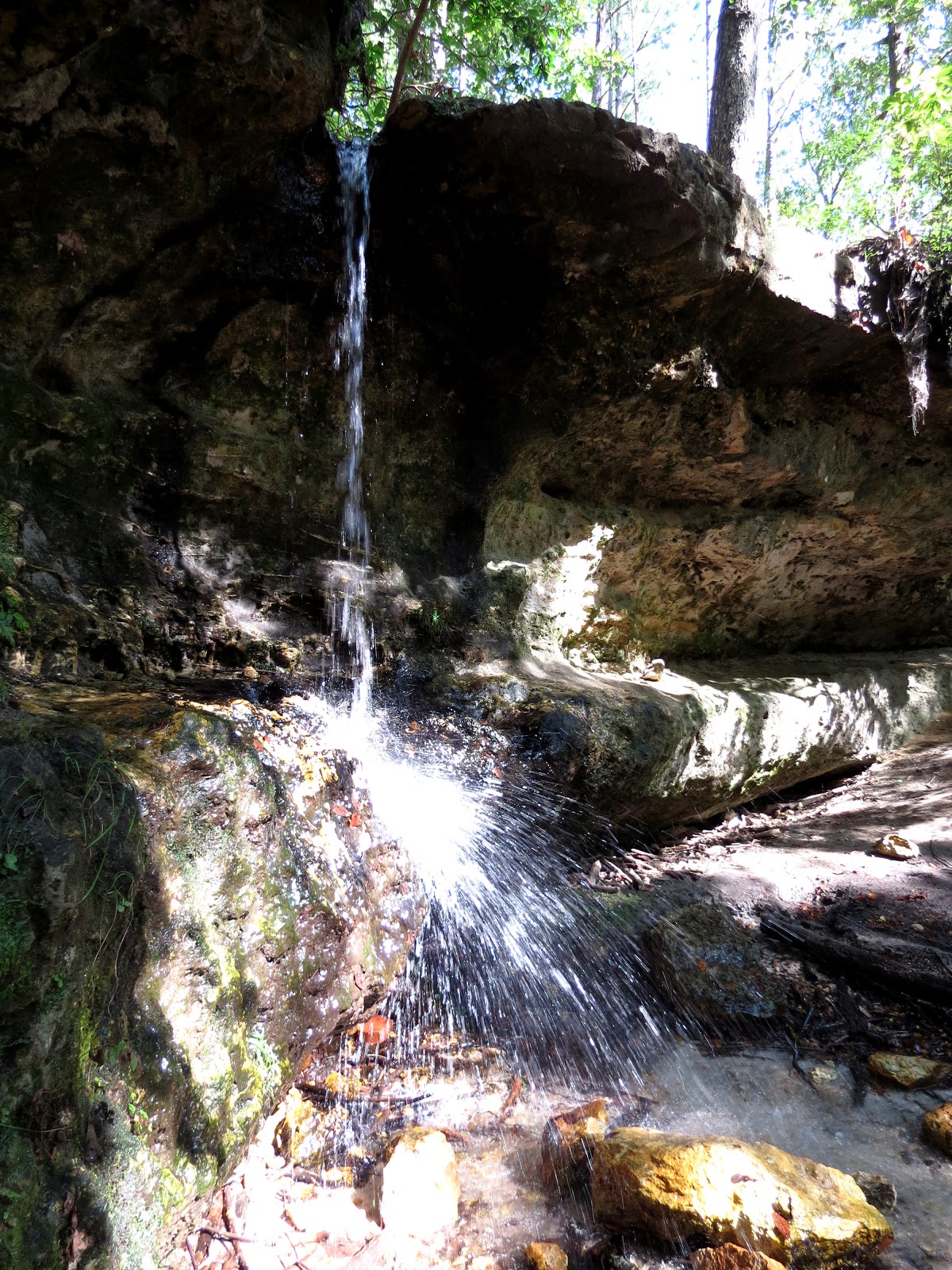
Sure, it's more of a water trickle than a water fall, but I'll take it.  I climbed up to the top of this sandstone hill to have a look at the stream that feeds the fall. If I came upon such a thing while tromping about in the woods, I probably wouldn't even notice it!

The stream that feed the falls

The same stream falling


Here's a view over the edge.  Well, sort of.  I have no fear of heights as far as I know, but I tend to have a problem with vertigo-like symptoms near drop offs or on open faced stairs.  Weird.

A peek over the edge


And a view of Peachtree Rock from Peachtree Falls:


After taking a family picture of a dude with his two kids, I moved on.  It was obvious that the trail was much less traveled from this point on.  The Rock was probably less than half a mile from the parking lot, and I think a lot of people just nip in to this part of the preserve and never see the rest.

Not far from the Rock I stopped to check out some birds flitting about.  Turned out to be a few Pine Warblers and a Black-and-White Warbler, the second I've seen this season.


I hiked through the woods for a bit longer, passing a barrel from an old still, and then the terrain opened up and became sandier.


I found a flycatcher or something perched on a tree in a field that I wasn't supposed to be in.


I was drawn into the restricted field by the knocking of a woodpecker.  I had read something about Red-Cockaded Woodpeckers around here.  At CONG we strive to preserve the habitat of this endangered species, but they haven't been seen in the park since the late '90s.  They do nest a few miles from the park, so perhaps one day they will come back.  At any rate, I would not have minded seeing one at Peachtree.  But, I never found the source of the knocking.  It's surprising how hard it can be to pinpoint where such a sound is coming from.

I snapped a shot of a cool lizard, an Easter Fence Lizard (aka Fence Swift).  It was nice to see something other than the Broad-headed and Five-lined Skinks and Anoles I've been looking at for the last year. 


I also saved the life of a grasshopper!  This big ol' sucker came flying at me then veered off and landed beside the trail.  I didn't realize what was going on until I noticed the bird (a Red-eyed Vireo I believe) a few feet from me.  The bird decided that it didn't want to fight me for its lunch and flew off while I snapped a photo of the hopper.  It's amazing how well camouflaged this this is.


I continued hiking through the pine trees that skirted the backside of the aforementioned field.  There was lots of bird activity back here.  I can't believe how many Brown-headed Nuthatches I saw, they were all over the place!  I didn't get a picture, but I took a short video of one going at a pine cone up in a tree.  (I'll spare y'all the video, it's little more than a silhouette anyway.)  I also spotted several more Pine Warblers back here.


The trail wrapped around the field then continued along another undulating, ridge-like area.  I found a wicked-cool, gnarly tree.


 It started getting rockier again, and there were some pretty nice views.


I ran into a pack of kids as I came to the last major landmark, Little Peachtree Rock.  It's not as phenomenal as Peachtree Rock, but I think I like it better.  It's beautiful standing out in the sun, and I had a great day for it!


LPTR still has initials and whatnot carved into it, but it has not been as tortured as PTR, no doubt because of the lighter traffic in this part of the preserve.  It's not blocked off either.  In fact, the trail (treacherous though it may be) goes right past it---watch your step, those stairs are rickety and uneven!


It's a wonder this thing is still standing.  You lightly touch the rockface and the sand just slides right off onto your hand.  It's fascinating to lay your hand on this monolith that was created when this area was under the ocean (the holes you see in the rock are fossilized burrows of marine worms) and realize that the slightest touch schluffs bits of it off.  I think it looks like a camel, not a peach tree.


 After LPTR, the trail wraps back around, under the Rock, and opens up into an area covered with blinding white sand, the kind of sand you expect to find at a nice beach (except for the pinestraw), before looping back around to the trail leading out to the parking lot.


There are a few others trails at this preserve that I'll have to check out in the future.

As far as the book, 50 Hikes in South Carolina, 2 down, only 48 more to go---the Oakridge Trail in CONG is the other that I have checked off.


A side note---Well done to the SAR teams working in Glacier NP that spent the weekend searching for the two missing hikers and recovered them this afternoon alive and in good health! 


Sunday, October 14, 2012

Congaree River Blue Trail

A couple of weeks ago I finally got the chance to paddle the Congaree River Blue Trail (you can find a PDF of the trail map here).  This is a 50 mile designated recreational paddling trail that starts in Columbia and ends at Hwy 601, on the other side of Congaree National Park. 

I went with Vikki, Brian, Carol, and David.  We staged one car at the 601, one at the park visitor center, and left two at Casey Landing where we put in.  Casey landing is at mile 3 of the trail, so we had 47 miles to go.  The first order of business was for Vikki to take off her shoes and get in her boat.  Sure enough, this being a public landing, she stepped into the water barefoot, right onto a piece of glass. 

 
But, we weren't letting a little injury slow us down!  David helped her get it cleaned off and bandaged and we were on our way!


It's a hassle dealing with a non-waterproof camera while in the boat, so most of these pictures will be from our stops at sandbars along the way.  We paddled for an hour or so before stopping to stretch our legs.  The current in the Congaree is not very fast, but it is enough to keep you going, and it was pretty easy paddling.

The water would get pretty shallow near the sandbars, so it was seldom possible to paddle all the way up to land and we usually had to drag the boats the last little way.


I guess Vikki made it all the way up to the shore this time, I can't imagine that she climbed back into her boat to have a snack.


Our sandbar stops varied from 15 minutes to 45 minutes, depending on what was going on and how we were feeling, then we were off again.


The first day on the water was pretty uneventful.  There was not much motorized boat traffic. 


A couple of guys in a canoe had set out about an hour and a half before us.  We caught sight of them not far downstream from us, but we were coming up on the park and stopped at the sandbar off the river trail for a while, and we never caught back up to them.  (The next day we saw that they had camped a ways downstream from us.)


On this particular Saturday, the Migration Bird Count was going on.  Kathleen, a former seasonal ranger and birding friend, had called me the night before to try to get me to help with the count.  She was disappointed that I was not going to be in the park, until I told her what I was going to be doing instead.  The Congaree river is not park property, but a 25 miles stretch of it forms the park boundary, so any birds counted there are fair game!

When we came along next to the park, I started counting.  The first thing I saw was a Belted Kingfisher (we saw tons of these), then I heard a White-eyed Vireo.  My third count was the energetic, occasionally elusive O'Grady Katbird!  Kathleen was on the river trail calling out to us, what timing!  We chatted with her for a few minutes, then went on our way. 

We made camp on a large sandbar on the park side 24 miles into our trip.  Being on the park side, we weren't able to have a campfire, but that was no big deal.  We landed there around 5 (maybe).  We took our time setting up camp and securing the boats.


I set up my tent in a secluded spot near the water's edge.


The weather was meant to be nice, with a change of rain for about half an hour that evening.  This would be a bad spot if it rained because the river would rise up to greet me, but I decided to risk it. (This is not foreshadowing, it was clear all night.)


We spent the evening in a central "kitchen" area. 


Vikki thoroughly enjoyed a rare treat, Tostitoes and Salsa, for dinner.


David broke out a bottle of wine before we started preparing dinner.  Carrying extra things like wine, corkscrews, chairs, etc., is one of the nice things about kayak camping.


 David, Carol, and I grilled steaks while Brian opted for a fancy MRE.  Vikki's chips had served her well, and her MRE went unEed.


We relaxed in the sand listening to some low music---Bad Company and Alice Cooper among other stuff.  One of the many things I enjoy about spending time with friends not of my generation is their much better taste in music. 


As the sun set, the Barred Owls began their serenade.  They were talking back and forth from both sides of the river all evening.  They would respond to each other, then I would call to them and they would call back.  We managed to keep Vikki's horrendous attempt at a Barred Owl call out of the mix that night!


The moon was big enough and bright enough that we were able to enjoy the experience well into the night without flashlights.  The conversation was good, but the water was calling.  The three adventurous ones of the group (the women, of course) opted for an al naturale dip in the river.  I'm pretty sure that at this point in the evening the owl calls became louder and more frequent! 

I'm not sure what time we turned in, a bit before midnight I think.  I never sleep terribly well when camping, but I think everyone else was out pretty quick. 

We all rose with the sun the next morning. 


The water had gone down several shore feet.  If you click on the above picture to enlarge it, you will see a small vertical stick in the foreground just to the left of the center of the image.  This stick marked the water level the evening before.  Looking out across the river, there were a few logs sticking up that had been fully submerged the previous day.

We took our time breaking camp and packing the kayaks, and we headed back out around 8:15.


Now is a good time to talk a little about the kayaks.  The river had started to wind more, and we were further from the fall line (I don't know how much that matters), and there seemed to be less of a current.  Every one was paddling 14 ft boats, everyone but me.  I was in Vikki's old 10ft Perception.  The day before they were a little worried about me doing the river in a 10 ft boat, and were constantly asking me how I was, how the boat felt, etc.  I didn't really get it.  I was certain that they were all more comfortable than I, but having not paddled one of the "Cadillacs", I couldn't tell the difference, and I was happy in my ignorance.  I wanted to maintain my ignorance.  But, on the morning of the second day, I kept falling behind.  I didn't get it.  I was busting my ass to keep up, they were paddling leisurely, and I was still falling back.  Then I started counting the strokes.  For every stroke they were making, I was making two, and I still couldn't keep up.  When I realized this, I stopped trying so hard and made more of a point to enjoy the trip.  We chatted about this at our first stop, and they slowed it down a little, we were still making great time.

Being  in the back, I was able to get some neat shots that showed the towering treeline as we paddled into an area where the banks of the river rose in steep slopes.


The red-clay bluffs that we paddled along were pretty neat also.


We stopped at a sandbar around midday. 


I love pictures of kayaks along the shore.


While on this sandbar, Brian discovered a curious bush.  We all went to investigate.


We suspected that it might be an invasive species.  My battery was running low, so Carol whipped out her phone to do some research.


We couldn't get a strong enough signal for surfing the web, so eventually we gave up.  Vikki looked it up later, and it was Christmas Cherry, the invasive species that we had suspected.


As we were preparing to set out again, David seemed to be seriously contemplating the mysteries of the universe.


But I guess he figured it out and things weren't so bad after all!


Back on the river, we tried to get some cool group (nearly) shots.


Later in the afternoon we pulled up on another sandbar.


This one was strewn with rocks.  A couple of previous ones had been as well.  Everyone started wondering about gazing at the ground, occasionally stooping to check out something.  This is what we had been doing on all of the sandbars that were not just sand.


As the water of the Congaree river rises and then recedes, is takes with is some of the sand on the sandbars.  On some of these sandbars, this reveals a new layer of rocks, and amongst these rocks, one can often find shards of pottery left behind by those that went before us, namely the Congaree Indians. 


David was the real pottery shard hunter, but each of us found a few interesting, patterned pieces.  We were hoping to find an arrowhead or spear-point, but that was not to be on this trip.  Perhaps next time.

We headed out on the last stretch of the trip, finishing up our 47 miles.  We paddled by a cool looking bird that paid little attention to us, an Anhinga, sometimes called a water-turkey or snake-bird. 


Boat traffic increased as we came up on the 601 take out.  The railroad bridge just before the Hwy 601 bridge was under construction.  It was an interesting sight from our angle.


Often you will see trailers suspended from cranes at construction sites along highways.  I never gave this much thought, but apparently these are their compressors, suspended to prevent theft.  We cracked up when we passed by and saw that, not only were their compressors suspended, but there was a John boat dangling from the crane as well!


We made it to the take out, hauled the boats up, and Carol and I loaded our stuff into David's truck.  Then Carol, Vikki, and I loaded ourselves into David's truck.  Vikki and I were going to ride in the back, but David wasn't hearing that, there wasn't even an argument to be had, so we all snuggled into the cab.  We dropped Vikki off at her car in the park, then David took Carol and myself back to Casey Landing to retrieve our vehicles. 

Then I went home and went to bed!